On 8 May 1941, Harvard 2884 crashed, killing instructor B.L. Duffey and Australian trainee D M Lord at a location 2-1/2 miles south of Ottawa’s Uplands Airport on the farm of Mr. Jervis Craig. The accident was mentioned in my 19 April blog post Ancestry adds Canada, Royal Canadian Air Force Crash Cards, 1939-1945 .
I was interested to pinpoint the location. It seemed unlikely to be exactly due south of the airport, so I started looking for the Jervis Craig farm. Thinking it could be on either side of the Rideau River I looked for him in the 1921 census. He was there on the west (Nepean) side as Gervais Winfield Craig, age 19, a wage earning farmer, eldest surviving son of John and Clara. There was a younger brother, Walter David Craig, age 4.
A record at Find a Grave, also at TONI and Canadian Headstones, showed Gervais W. Craig, birth 10 Dec 1901, death 5 Mar 1983, buried at Our Lady of the Visitation Roman Catholic Cemetery, South Gloucester. That’s on the east side of the Rideau River.
My next step was to consult asessment records for Nepean for 1939, requiring a trip to the Ottawa City Archives. I chose 1939 as there was a newspaper report that he was involved in a traffic accident at Black Rapids that year. I found the family headed by John and Clara, but no mention of Gervais. His brother Walter David Craig was there with the notation RCAF.
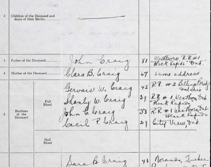
 Walter’s service file is available as he died on a bombing raid over Germany. Among the list of siblings is Gervais W Craig, RR 2 Billings Bridge, on the east (Gloucester) side of the Rideau River. I scheduled a trip to back to the City Archives to consult Gloucester assessment records.
In the meantime, it occurred to me to look for a compiled family history. Nothing at Ancestry, FamilySearch or WikiTree, but on MyHeritage there was a Craig family tree with a biography mentioning that “Gervie had a farm on the Limebank Road just north of (Earl) Armstrong Road in Gloucester Twp. The farm was sold to Campeau Homes around 1969 … homes have recently been constructed on this farm as part of Riverside South.”
That would be Lot 20, Con 2 RF of Gloucester Township which is about 3.5 miles from the airport, depending on exactly where you measure to and from.
Family history friend Ken McKinlay, Ontario land record guru, found the Abstract/Parcel Register Book page at https://www.onland.ca/ui/4/books/80337/viewer/454242720?page=67 showing the property came into possession of the Craig family in the 1850s, and was granted to Gervais in 1939 and 1943 for “Nat. love & $1.”
A lesson for me is to begin with the low hanging fruit, compiled genealogies across the range of sites. Even through they often have errors, they can give research a running start before venturing far into original records.
Acknowledgments to Glenn Clark, President of the Gloucester Historical Society for advice on the geographical area of RR 2 Billings Bridge, and Ken McKinlay, who blogs at Family Tree Knots, for untangling me from the puzzles that are Ontario land records.


Very interesting, well done. It also demonstrates that one record leads to another and slowly (or quickly in some cases), the pieces fall into place. The story is also a good example of research perseverance, something we could all use more of!